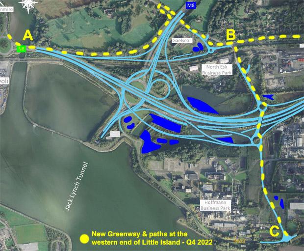
This week, a major part of the Dunkettle Interchange project was completed with the opening of a western route into Little Island. This is shown in the map above going from B to C and is about 1km in length.
This is important from a cycling point of view because it opens up new routes for cyclists to take in Little Island as part of a cycle.
If we go back just a few years, there was no easy way to get to these roads without having to negotiate the old Dunkettle Interchange or take the longer hilly diversion via Glanmire.
Now, someone in say Glanmire can cycle safely on the flat down to the Dunkettle Roundabout... along the 'new' Greenway (A to B) to get to Bury's Bridge near the Gaelscoil... and now across the new western road into the Little Island and a new network of roads.

The photo below is an aerial view of point 'B' on the map near Bury's Bridge.

You can see the new Greenway heading East towards Glounthaune under construction.
'Structure 16' is the new pedestrian bridge over the railway line.

The image above is an aerial view looking south from point 'B' on the map... pretty much over the railway pedestrian bridge.
It shows the new walkway and cycle lane, the 'Northern Roundabout' and 'Structure 01' which is the new bridge over the N25.
At the top right, you can see part of the 'Southern Roundabout' and the road heading south into Little Island.
See some photos of the route I took below.

The photos are in sequence from 1 to 7. They start at the most southerly point which is the small roundabout at the western part of Little Island and then proceed north.

Photo 1: The photo above is the shared footpath and cycling path at the small roundabout in Little Island. This is the view looking west and the new link road is at the top right.

Photo 2: The photo above is the view approaching what is termed the 'southern roundabout'. The walkway on the right has a smooth tarmac surface and is about 3-metres in width.

Photo 3: The photo above is is the view of the path at the 'southern roundabout'. There is a gap where there will be a future slip road for cars exiting the N25 below.

Photo 4: The photo above is the view of the bridge linking the southern and northern roundabouts. The key thing here is that they have kept the path nice and wide so that there's plenty of space.
Photo 5: The photo above is the view of the path at the northern roundabout. The traffic cones where there is a gap in the path for a future slip road to go down onto the N25 below. The bypass continues south at the far left of the photo.

Photo 6: The photo above shows the view of the path as it heads away from the northern roundabout and towards the northern end of this new link road. Again, there is a nice wide 3-metre shared path for pedestrians, runners and cyclists.

Photo 7: The photo above is the view of the pedestrian bridge over the railway line.

Photo 8: And the final photo above is of the zebra crossing allowing pedestrians and cyclists to cross over to the Greenway path on the other side. That is part the new Greenway path which will go from Dunkettle Roundabout to Glounthaune / Carrigtwohill & Midleton.
In conclusion: The most immediate impact is that this new road opens up safe cycling options for many of the people that work or live in Little Island. For the recreational cyclist, it opens up the quieter roads of Little Island to explore are part of a cycle.


No comments:
Post a Comment
All comments are moderated and need to be approved before they appear on this blog.