Pages

Blackwater Valley Cycle Route - Maps & Signs - Youghal to Fermoy


The Blackwater Valley Cycle Route goes from Midleton in East Cork to Rathmore in Co Kerry and covers a distance of about 160kms. This was a tourist initiative launched around the turn of the century.

More info in this overview post.

In this post, we'll look at the section from Youghal to Fermoy which is about 48kms long. We'll look at what old maps and signs are still present on the route as of August 2023.

As can be seen from the map above, the route goes from Youghal to Mount Uniacke and Ballynoe on reasonably quiet roads. After Ballynoe, it starts off quiet but it joins the busy R628 road to the east of Conna. The route follows this busy road until the crossroads at Aghern where the route turns right onto mostly quiet country roads as far as Fermoy.

For information on the sign in Youghal, see this earlier post.

Mount Uniacke - Map Board : The information sign for the route is located at a junction at the south-eastern approach to the hamlet of Mount Uniacke.


This is the notice board in more detail...


This is the original map cleaned up a bit to make it clearer....


Ballynoe - Map Board : The information sign for the route is located outside the community centre in Ballynoe.


This is another view of it...


This is a close up of the map on the notice board.


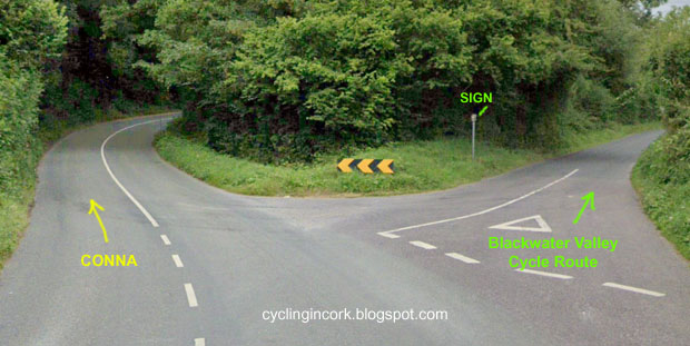
Ballynoe to Conna Road Junction : About 2kms to the north of Ballynoe, there is a second Y junction on the road to Conna. It is along this short section that the first of the brown direction signs appear on the route.


The shortest route to Conna at the Y-junction is on the left but the Blackwater Valley Cycle Route takes a right here.... point A on the map.


If you look carefully, there is a small sign on a metal post to show the cyclist the correct direction.


The photo above taken in August of 2023 shows that the sign is still in place after all these years. The sign on the opposite side is the same and is for cyclists coming in the opposite direction. 


About 2kms down the road, the next junction is marked as B on the map. As can seen, there is a brown sign on the right.


The photo above shows the sign from the Ballynoe / west side. It has some damage due probably to hedge cutting but it's still intact.


The photo above shows the other side (east side) with some minor damage as well.

After another 400m or so, we come to the next junction marked as C on the map.


It's hard to make out but the route sign is over on the right hand side and almost buried in the hedge.


After removing a bit of the overgrowth, this is what it looks like...


Again, it shows some signs of damage but it's still mostly intact.


The photo above shows the sign from the other side (east side).


The photo above shows the same sign but also shows the road looking back up the road in the direction of Ballynoe. This is a nice quiet country road inside a wooded valley and perfect for cycling.

If we now turn around and continue the journey north, this minor road finally comes out at a T-junction on the R628 road about 3.5kms to the east of Conna.


At the right hand side of this junction, there are two direction arrows for the route. Other than a bit of lichen, it's in a very good condition and pointing in the correct directions.

The Google Streetview images from April 2009 and August 2011 show no signpost here. The August 2019 image shows the pole bent over at a 45 degree angle but it was straightened by the time of the July 2022 image. The photo above is from the start of September 2023.

Conna - Map Board : The notice board for the Blackwater Valley Cycle Route is located outside Conna Castle which is at the eastern side of the village.


This is a close up of the notice board...


This is the map on the board in Conna. It shows the route from Ballynoe and the turn north at the crossroads at Aghern.


Aghern - Map Board : The notice board for the Blackwater Valley Cycle Route is located at the Aghern Amenity Area which is a small grassy triangle on the north bank of the River Bride.


This is a photo of the notice board in August of 2023 and it looks remarkably clean for such an old sign.


This is a close up of the map and it shows the next section of the route to Fermoy.


For this one, the gradient map is actually important as there is a significant climb before dropping down into the town of Fermoy.

Right at Kenny's Crossroads : As can be seen from the map above, there is a sharp turn to the right and north on the route to Fermoy. 


This is Kenny's Crossroads. According to Google Streetview, there was a second signpost there as of September 2019 showing the directions for the Blackwater Valley Cycle Route. This signpost is missing in the July 2022 Streetview images. When I was at this location in August of 2023, the second signpost was still missing.

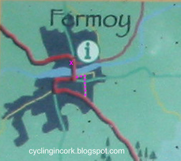
Entering Fermoy: The image below shows a closer view of the Blackwater Valley Cycle Route going through the town of Fermoy. The red line shows what is supposed to be the official route.


However as you enter Fermoy, there is a sign at the junction of Richmond Hill and College Road  instructing cyclists to turn right. I have this route plotted in a series of purple dots as far as the river and west then to the bridge over the River Blackwater.


The photo above shows the sign at the road junction. It's very easy to miss considering that the cyclist is coming down a steep hill, the sign is well in on the left and it's mostly obscured.


I removed some of the ivy and the sign is still in remarkably good condition.

Fermoy - Map Board : The notice board for the Blackwater Valley Cycle Route is located outside Fermoy Town Park which is on the north side of the River Blackwater.


This is the sign in more detail...


An enlarged view of the map shows the route between Aghern and Glanworth.


In Summary... After all these years, the signage for the Blackwater Valley Cycle Route from Mount Uniacke to Fermoy is still in a reasonable condition. There is certainly enough information for a cyclist to follow the route in 2023. Considering how much of the signage is intact, it's just a pity that the notice boards with maps were removed in Midleton and Youghal.

For more information on the entire route, see the overview post.

Blackwater Valley Cycle Route - Maps & Signs - Midleton to Youghal


The Blackwater Valley Cycle Route goes from Midleton in East Cork to Rathmore in Co Kerry and covers a distance of about 160kms. This was a tourist initiative launched around the turn of the century.

More info in this overview post.

In this post, we'll look at the first section from Midleton to Youghal which is about 31kms long. We'll look at what old maps and signs are still present on the route as of August 2023.

Original Map... The official map for the original route can be seen on the board that is located in Ladysbridge. The map is shown below...


As can be seen, the route starts in Midleton, heads south to Ballinacurra and then heads east to Ladysbridge. From there, it follows the R633 to Youghal. As the route enters Youghal, it turns south to Claycastle Beach and follows the coastline into the town.

The light Blue line is the N25. You'll notice that the Youghal Bypass (opened 2004) is not included so the map is quite old.


The towns of Midleton and Youghal are shown above in more detail. The 'i' refers to the fact that there is information about the route in the town, not the exact location of the information point.

On the map of Midleton, the route is the red line with a black line under it. It's a bit hard to make out but the line starts near the entrance to Distillery Walk.

The original route takes the cyclist south up St Mary's Road and down to the Lake View Roundabout on the N25. This can be a very busy junction and a much better alternative now is to use the Ballick Road to get to Ballinacurra. This is especially true now as a new Greenway to Ballinacurra is being built as of 2023. 

Midleton - Map Board : The official start for the Blackwater Valley Cycle Route is on Distillery Walk which is outside the Jameson Distillery.


The image capture above from Google Streetview shows that the information sign for the route was in place up until at least July 2019. An image captured from Main St shows that it was gone by September 2021. This is what it looks like in August of 2023...


Using a screenshot from Google Streetview, this is what the notice board looked like in Midleton but the quality is pretty poor.


The map on it looks identical to the one that is in Ladysbridge.

Ladysbridge - Map Board : The notice board for the Blackwater Valley Cycle Route is located outside St Joseph's Cemetery which is on the Ballymacoda road on the eastern side of the village.


This is a close up of the notice board...


There is some gradient information about the route but it's pretty basic.


Youghal - Map Board : The notice board for the Blackwater Valley Cycle Route used to be located at the western wall of the tourist office in the town. According to Google Streetview, the sign was removed sometime between August 2011 and June 2018.


This is the view in August of 2023 which shows that the notice board is still absent.


In Summary... The signage for the Blackwater Valley Cycle Route now only exists in Ladysbridge for this section of the route after the notice boards were removed in Midleton and Youghal. This is unfortunate as these towns are starting points for tourists wishing to travel the entire route.

For more information on the entire route, see the overview post.

Blackwater Valley Cycle Route in Co Cork - Overview


In August of 2023, I cycled the Blackwater Valley Cycle Route in Co Cork over the course of three days. In this post, I'll give an overview of the 161km route from Midleton in East Cork to Rathmore in Co Kerry. In the other posts listed below, I'll give a breakdown of what notice boards and signs are left on the route. I'll also give a detailed description so that others to try to cycle parts or all of the route.

Updated 1st Sept 2023

Maps & Signs...An inventory of what notice boards and signs are left on the course of as August 2023.

1) Midleton to Youghal - Maps & Signs

2) Youghal to Fermoy - Maps & Signs 

3) Fermoy to Doneraile - Maps & Signs

4) Mallow, Ballyclough, Buttevant, Doneraile loop - Maps & Signs (future post)

5) Kanturk to Rathmore - Maps & Signs (future post)

Modern Route... Description

1) Midleton to Youghal - Directions (future post)

2) Youghal to Fermoy - Directions (future post)

3) Fermoy to Doneraile - Directions (future post)

4) Doneraile to Kanturk via Buttevant (option 1 - northern route) - Directions (future post)

5) Doneraile to Kanturk via Mallow (option 2 - southern route) - Directions (future post)

5) Kanturk to Rathmore - Directions (future post)

Map of the route...


The Blackwater Valley Cycle Route starts in the town of Midleton in East Cork and ends in Rathmore on Co Kerry, a distance of approximately 161kms or 100 miles.

The route seems to have been an initiative to promote tourism in Co Cork as it doesn't follow the Blackwater river north to Cappoquin and Lismore in Co Waterford and it stays mostly within the confines of the county of Cork.

According to online source, there doesn't seem to be any printed maps or leaflets for the route. Instead, notice boards were placed in several key points along the route. Most of these are still intact although they're showing their age at this stage.

The image below shows what the original sign for Kanturk looked like...


As can be seen, there is an outline of the full route on the left and a more detailed local map on the right with some gradient information below it. Similar notice boards were put up in the villages and towns along the route.

How old is the route???.. Looking at Google Streetview, the information boards were in place in 2009 so the route pre-dates that. On the overall map, the Youghal Bypass and the Ballincollig Bypass are not shown so it's possible the route predates their opening dates of 2004 and 2003 respectively.

Judging by the weathering on the signs and the information above, the early 2000's would seem like a good guess.

Current Status... As of the Summer of 2023, this is as far as I can tell the status of the information boards on the route based on my own observations and by examining Google Streetview...

Location - Distance from start - Status of notice board
Midleton - Start - Board removed between 2019 and 2021
Ladysbridge - 12kms - Visited Aug 2023. Still in place
Youghal - 31kms - Board removed between 2011 and 2018
Mount Uniacke - 43kms - Visited Aug 2023. Still in place
Ballynoe - 55kms - Visited Aug 2023. Still in place
Conna - 59kms - Visited Aug 2023. Still in place
Aghern - 63kms - Visited Aug 2023. Still in place
Fermoy - 75kms - Visited Aug 2023. Still in place
Glanworth - 83kms - Visited Aug 2023. Still in place
Castletownroche - 91kms - Visited Aug 2023. Still in place
Doneraile - 103kms - Visited Aug 2023. Still in place
Buttevant - 110kms - Visited Aug 2023. Still in place
Kanturk - 130kms - Visited Aug 2023. Still in place
Banteeer - 135kms - Visited Aug 2023. Still in place
Millstreet - 150kms - Visited Aug 2023. Still in place
Rathmore - 161kms - Unable to locate

The list above shows the shortest route going from Doneraile to Kanturk via Buttevant. There also seems to be an option of an a more southerly route via Mallow after Doneraile which adds 5kms to the overall route.


Option 2 after Doneraile...
Mallow - 115kms - Cycle route map has been removed from the board.
Ballyclough - 123kms - Visited Aug 2023. Still in place
Kanturk - 135kms

Sign at Mount Uniacke in July of 2023... still in place but showing its age

Forgotten Route... As of 2023, the route is probably at least 20-years old and it seems to be long forgotten. I called into one of the more popular tourist offices in a town along the route and they had never heard of it.

It seems to follow the pattern of a lot of other tourist initiatives... a walking or cycling route is proposed, funding is provided, signs are put up and then there is no maintenance and it is largely forgotten about.

In Conclusion... Truth be told, it probably isn't the nicest of cycling routes. While the route avoids the main roads, some of the roads are still reasonably busy and are certainly not 'quiet back roads'. In terms of a good experience and views, tourists would be better served by following the EuroVelo1 route along the coast rather than this inland route.

Having said that, the Blackwater Valley Cycle Route isn't the worst route either and the whole route or parts of it could be used as an excuse for a cycle.

Back Story... During a long cycle in the Summer of 2023, I came across a sign in Conna in NE Cork for the 'Blackwater Valley Cycle Route'. The sign itself looked quite old and it was something I had never heard of.

Once I got home, I tried to tried to search online for any information about the route and I had some limited success. This is the description given on various websites... 

"The Blackwater Valley Cycle Route is approximately 156 km and starts in the historic Heritage Town of Youghal, County Cork and ends in Killarney, County Kerry. The route first runs Northwest towards Fermoy and the Blackwater and then generally west towards Killarney.

The route is divided into four sections and the end point of these sections has been influenced by the availability of overnight accommodation in the general area. Please note that this is not an official route, and it is not signposted as a cycling route or mapped.

The Blackwater Valley Cycle Route can be divided into sections and the following are suggested cycling schedules:
Day 1: Youghal – Fermoy 43 KM
Day 2: Fermoy – Kanturk 54 KM
Day 3: Kanturk – Millstreet 21KM
Day 4: Millstreet – Killarney 38 KM.
"

Mallow.ie has the following description... "The Blackwater Valley Cycle Route is a 191 km long spanning from Rathmore to Midleton. The route passes through 18 villages and towns including Mallow. The beauty of "The Blackwater Valley Cycle Trail" is that it can be joined at any stage and that it boasts numerous cultural and heritage sites. The trail is also close to a wide range of activities from Fishing to Hot Air Balloon rides!! A loop section encompassing Mallow, Ballyclough, Buttevant and Doneraile can also be cycled and the trail is fully signed."