The Blackwater Valley Cycle Route goes from Midleton in East Cork to Rathmore in Co Kerry and covers a distance of about 160kms. This was a tourist initiative launched around the turn of the century.
More info in this overview post.
In this post, we'll look at the section from Youghal to Fermoy which is about 48kms long. We'll look at what old maps and signs are still present on the route as of August 2023.
As can be seen from the map above, the route goes from Youghal to Mount Uniacke and Ballynoe on reasonably quiet roads. After Ballynoe, it starts off quiet but it joins the busy R628 road to the east of Conna. The route follows this busy road until the crossroads at Aghern where the route turns right onto mostly quiet country roads as far as Fermoy.
For information on the sign in Youghal, see this earlier post.
Mount Uniacke - Map Board : The information sign for the route is located at a junction at the south-eastern approach to the hamlet of Mount Uniacke.
This is the notice board in more detail...
This is the original map cleaned up a bit to make it clearer....
Ballynoe - Map Board : The information sign for the route is located outside the community centre in Ballynoe.
This is another view of it...
This is a close up of the map on the notice board.
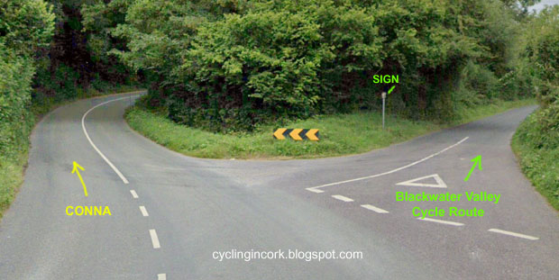
Ballynoe to Conna Road Junction : About 2kms to the north of Ballynoe, there is a second Y junction on the road to Conna. It is along this short section that the first of the brown direction signs appear on the route.
The shortest route to Conna at the Y-junction is on the left but the Blackwater Valley Cycle Route takes a right here.... point A on the map.
If you look carefully, there is a small sign on a metal post to show the cyclist the correct direction.
The photo above taken in August of 2023 shows that the sign is still in place after all these years. The sign on the opposite side is the same and is for cyclists coming in the opposite direction.
About 2kms down the road, the next junction is marked as B on the map. As can seen, there is a brown sign on the right.
The photo above shows the sign from the Ballynoe / west side. It has some damage due probably to hedge cutting but it's still intact.
The photo above shows the other side (east side) with some minor damage as well.
After another 400m or so, we come to the next junction marked as C on the map.
It's hard to make out but the route sign is over on the right hand side and almost buried in the hedge.
After removing a bit of the overgrowth, this is what it looks like...
Again, it shows some signs of damage but it's still mostly intact.
The photo above shows the sign from the other side (east side).
The photo above shows the same sign but also shows the road looking back up the road in the direction of Ballynoe. This is a nice quiet country road inside a wooded valley and perfect for cycling.
If we now turn around and continue the journey north, this minor road finally comes out at a T-junction on the R628 road about 3.5kms to the east of Conna.
At the right hand side of this junction, there are two direction arrows for the route. Other than a bit of lichen, it's in a very good condition and pointing in the correct directions.
The Google Streetview images from April 2009 and August 2011 show no signpost here. The August 2019 image shows the pole bent over at a 45 degree angle but it was straightened by the time of the July 2022 image. The photo above is from the start of September 2023.
Conna - Map Board : The notice board for the Blackwater Valley Cycle Route is located outside Conna Castle which is at the eastern side of the village.
This is a close up of the notice board...
This is the map on the board in Conna. It shows the route from Ballynoe and the turn north at the crossroads at Aghern.
Aghern - Map Board : The notice board for the Blackwater Valley Cycle Route is located at the Aghern Amenity Area which is a small grassy triangle on the north bank of the River Bride.
This is a photo of the notice board in August of 2023 and it looks remarkably clean for such an old sign.
This is a close up of the map and it shows the next section of the route to Fermoy.
For this one, the gradient map is actually important as there is a significant climb before dropping down into the town of Fermoy.
Right at Kenny's Crossroads : As can be seen from the map above, there is a sharp turn to the right and north on the route to Fermoy.
This is Kenny's Crossroads. According to Google Streetview, there was a second signpost there as of September 2019 showing the directions for the Blackwater Valley Cycle Route. This signpost is missing in the July 2022 Streetview images. When I was at this location in August of 2023, the second signpost was still missing.
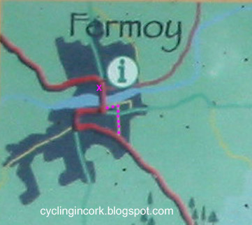
Entering Fermoy: The image below shows a closer view of the Blackwater Valley Cycle Route going through the town of Fermoy. The red line shows what is supposed to be the official route.
However as you enter Fermoy, there is a sign at the junction of Richmond Hill and College Road instructing cyclists to turn right. I have this route plotted in a series of purple dots as far as the river and west then to the bridge over the River Blackwater.
The photo above shows the sign at the road junction. It's very easy to miss considering that the cyclist is coming down a steep hill, the sign is well in on the left and it's mostly obscured.
I removed some of the ivy and the sign is still in remarkably good condition.
Fermoy - Map Board : The notice board for the Blackwater Valley Cycle Route is located outside Fermoy Town Park which is on the north side of the River Blackwater.
This is the sign in more detail...
An enlarged view of the map shows the route between Aghern and Glanworth.
In Summary... After all these years, the signage for the Blackwater Valley Cycle Route from Mount Uniacke to Fermoy is still in a reasonable condition. There is certainly enough information for a cyclist to follow the route in 2023. Considering how much of the signage is intact, it's just a pity that the notice boards with maps were removed in Midleton and Youghal.
For more information on the entire route, see the overview post.


No comments:
Post a Comment
All comments are moderated and need to be approved before they appear on this blog.